Sunday, May 15, 2011

Goa


Goa
गोंय
—  State  —

Seal
Location of Goa in India
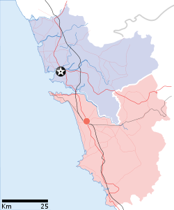
Map of Goa
Coordinates (Panaji): 15.563°N 73.818°E
Country India
Established30 May 1987
CapitalPanaji
Largest cityVasco da Gama
Districts2
Government
 - GovernorShivinder Singh Sidhu
 - Chief MinisterDigambar Kamat
 - LegislatureUnicameral (40 seats)
Area
 - Total3,702 km2 (1,429.4 sq mi)
Area rank28th
Population (2011)
 - Total1,457,723
 - Rank25th
 - Density393.8/km2 (1,019.9/sq mi)
Time zoneIST (UTC+05:30)
ISO 3166 codeIN-GA
HDIincrease 0.779 (medium)
HDI rank3rd (2005)
Literacy87% (3rd)
Official languagesKonkani*
Websitegoagovt.nic.in
^* Konkani is the sole official language but Marathi is also allowed to be used for any or all official purposes.
Goa ( /ɡ.ə/; Konkani: गोंय) is India's smallest state by area and the fourth smallest by population. Located in South West India in the region known as theKonkan, it is bounded by the state of Maharashtra to the north, and by Karnataka to the east and south, while the Arabian Sea forms its western coast. Goa is India's richest state with a GDP per capita two and a half times that of the country as a whole. It was ranked the best placed state by the Eleventh Finance Commission for its infrastructure and ranked on top for the best quality of life in India by the National Commission on Population based on the 12 Indicators.
Panaji is the state's capital, while Vasco da Gama is the largest city. The historic city of Margao still exhibits the cultural influence of the Portuguese, who first landed in the early 16th century as merchants and conquered it soon thereafter. The Portuguese overseas territory of Portuguese India existed for about 450 years until it was annexed by India in 1961.
Renowned for its beaches, places of worship and world heritage architecture, Goa is visited by large numbers of international and domestic tourists each year. It also has rich flora and fauna, owing to its location on the Western Ghats range, which is classified as a biodiversity hotspot.

Etymology

The name Goa came to European languages from the Portuguese, but its precise origin is unclear. In ancient literature, Goa was known by many names such asGomantaGomanchalaGopakapattamGopakapuriGovapuriGovem, and Gomantak. The Indian epic Mahabharata refers to the area now known as Goa, asGoparashtra or Govarashtra which means a nation of cowherds. Gopakapuri or Gopakapattanam were used in some ancient Sanskrit texts, and these names were also mentioned in other sacred Hindu texts such as the Harivansa and the Skanda Purana. In the latter, Goa is also known as GomanchalaParashurambhoomi is a name that the region is referred to in certain inscriptions and texts such as the Puranas. In the third century BCE, Goa was known as Aparantha, and is mentioned by the Greek geographer Ptolemy. The Greeks referred to Goa as Nelkinda in the 13th century. Some other historical names for Goa are SindapurSandabur, andMahassapatam.

History


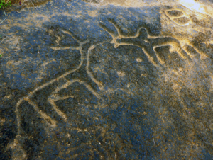
Rock cut engraving at Usgalimal
Goa's history stretches back to 8000-6000 BC. Early Paleolithic and Mesolithic rock art engravings have been found on the bank of river Kushavati at Usgalimal.Petroglyphs,cones,stone-axe,choppers dating back 10,000 years back have been found in many places in Goa like Kazur,Mauxim and the Mandovi-Zuari basin.Palaeolithic cave existence is seen at Dabolim, Adkon, Shigao, Fatorpa, Arli, Maulinguinim, Diwar, Sanguem, Pilerne, Aquem-Margaon etc. Difficulty in carbon dating the laterite rock compounds poses problems in determination of exact time period. These discoveries have shed light on Goa's prehistory.
Gold coins issued by the Kadamba king of Goa, Shivachitta Paramadideva. Circa 1147-1187 AD.
The Sumerians inhabited Goa around 2200 BC which was followed by several waves of Indo-Aryan people and the Dravidians from the Deccan. The early Goan society underwent radical changes when aboriginal locals and the migrants amalgamated, forming the base of early Goan culture.
In 3rd century BC, it formed part of the Mauryan Empire, ruled by the Buddhist emperor, Ashoka of Magadha. Buddhist monks laid the foundation of Buddhism in Goa. Between the 2nd century BCE and the 6th century CE, Goa was ruled by the Chutus of Karwar as feudatories of the Satavahanas of Kolhapur (2nd century BCE to the 2nd century CE), Western Kshatrapas (around 150 CE), the Abhiras of Western Maharashtra, Bhojas of the Yadav clans of Gujarat, and the Konkan Mauryas as feudatories of the Kalachuris. The rule later passed on to the Chalukyas of Badami, who controlled it between 578 to 753, and later the Rashtrakutas of Malkhed from 753 to 963. However from 765 to 1015, the Southern Silharas of Konkan ruled Goa as the feudatories of the Chalukyas and the Rashtrakutas. Over the next few centuries, Goa was successively ruled by the Kadambas as the feudatories of the Chalukyas of Kalyani. They patronised Jainism in Goa.
In 1312, Goa came under the governance of the Delhi Sultanate. However, the kingdom's grip on the region was weak, and by 1370 they were forced to surrender it toHarihara I of the Vijayanagara empire. The Vijayanagara monarchs held on to the territory until 1469, when it was appropriated by the Bahmani sultans of Gulbarga. After that dynasty crumbled, the area fell to the hands of the Adil Shahis of Bijapur who established as their auxiliary capital the city known under the Portuguese as Velha Goa.
The Sé Cathedral at Old Goa, an example of Portuguese influence
Coat of Arms of Goa as a Portuguese colony 1935–1961
In 1510, the Portuguese defeated the ruling Bijapur kings with the help of a local ally, Timayya, leading to the establishment of a permanent settlement in Velha Goa (or Old Goa).
In 1843 the capital was moved to Panjim from Velha Goa. By the mid-18th century the area under occupation had expanded to most of Goa's present day state limits. Simultaneously the Portuguese lost other possessions in India until their borders stabilised and formed the Estado da India Portuguesa, of which Goa was the largest territory.
After India gained independence from the British in 1947, Portugal refused to negotiate with India on the transfer of sovereignty of their Indian enclaves. On 12 December 1961, the Indian Army commenced with Operation Vijay resulting in the annexation of Goa, Daman and Diu into the Indian union. Goa, along with Daman and Diu was made into a centrally administered Union Territory of India. On 30 May 1987, the Union Territory was split, and Goa was made India's twenty-fifth state, with Daman and Diu remaining Union Territories.

Geography and climate


Geography


Goa coastline
Goa encompasses an area of 3,702 km² (1,430 sq mile). It lies between the latitudes 14°53′54″ N and 15°40′00″ N and longitudes 73°40′33″ E and 74°20′13″ E. Most of Goa is a part of the coastal country known as the Konkan, which is an escarpment rising up to the Western Ghats range of mountains, which separate it from the Deccan Plateau. The highest point is the Sonsogor, with an altitude of 1,167 meters (3,827 feet). Goa has a coastline of 101 km (63 miles).
Goa's main rivers are the Mandovi, the Zuari, the Terekhol, Chapora River and the Sal. The Mormugao harbour on the mouth of the River Zuari is one of the best natural harbours in South Asia. The Zuari and the Mandovi are the lifelines of Goa, with their tributaries draining 69% of its geographic area. These rivers are some of the busiest rivers in India. Goa has more than forty estuarine, eight marine and about ninety riverine islands. The total navigable length of Goa's rivers is 253 km (157 miles). Goa has more than three hundred ancient tanks built during the rule of the Kadamba dynasty and over a hundred medicinal springs.
Most of Goa's soil cover is made up of laterites which are rich in ferric aluminium oxides and reddish in colour. Further inland and along the riverbanks, the soil is mostlyalluvial and loamy. The soil is rich in minerals and humus, thus conducive to plantation. Some of the oldest rocks in the Indian subcontinent are found in Goa betweenMolem and Anmod on Goa's border with Karnataka. The rocks are classified as Trondjemeitic Gneiss estimated to be 3,600 million years old, dated by the Rubidiumisotope dating method. A specimen of the rock is exhibited in the Goa University.


Climate

Goa features a tropical monsoon climate under the Koppen climate classification. Goa, being in the tropical zone and near the Arabian Sea, has a hot and humid climate for most of the year. The month of May is the hottest, seeing day temperatures of over 35 °C (95 °F) coupled with high humidity. The monsoon rains arrive by early June and provide a much needed respite from the heat. Most of Goa's annual rainfall is received through the monsoons which last till late September.
Goa has a short winter season between mid-December and February. These months are marked by nights of around 21 °C (68 °F) and days of around 28 °C (84 °F) with moderate amounts of humidity. Further inland, due to altitudinal gradation, the nights are a few degrees cooler. During March 2008 Goa was lashed with heavy rain and strong winds. This was the first time in 29 years that Goa had seen rain during March.

Subdivisions


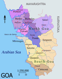
Talukas of Goa. Talukas in purple shades belong to North Goa district, and orange denote South Goa.
The state is divided into two districts: North Goa and South Goa. Panaji is the headquarters of the North Goa district and Margao of the south district. Each district is governed by a district collector, an administrator appointed by the Indian government.
The districts are further divided into eleven talukas – Talukas of North Goa are Bardez, Bicholim, Pernem, Ponda, Sattari and Tiswadi, the talukas of South Goa are Canacona, Mormugao, Quepem, Salcete and Sanguem. Headquarters of the respective talukas are Mapusa, Bicholim, Pernem, Ponda, Valpoy, Panjim, Chaudi, Vasco, Quepem, Margao and Sanguem.
Goa's major cities include Mapusa, Margao, Mormugao, Panaji and Vasco . The region connecting the first four cities is considered a de facto conurbation, or a more or less continuous urban area.

Flora and fauna


Equatorial forest cover in Goa stands at 1,424 km2 (549.81 sq mi), most of which is owned by the government. Government owned forest is estimated at 1,224.38 km2(472.74 sq mi) whilst private is given as 200 km2 (77.22 sq mi). Most of the forests in the state are located in the interior eastern regions of the state. The Western Ghats, which form most of eastern Goa, have been internationally recognised as one of the biodiversity hotspots of the world. In the February 1999 issue of National Geographic Magazine, Goa was compared with the Amazon and Congo basins for its rich tropical biodiversity
Goa's wildlife sanctuaries boast of more than 1512 documented species of plants, over 275 species of birds, over 48 kinds of animals and over 60 genera of reptiles.
Rice is the main food crop with pulses, ragi and other food crops are also grown. Main cash crops are coconuts, cashewnuts, arecanuts, sugarcane and fruits like pineapples, mangos and bananas.The State has a rich forest cover of more than 1,424 km². Goa's state animal is the Gaur, the state bird is the Ruby Throated Yellow Bulbul, which is a variation of Black-crested Bulbul, and the state tree is the Asan.
Rice paddies are common in rural Goa.
The important forests products are bamboo canes, Maratha barks, chillar barks and the bhirand. Coconut trees are ubiquitous and are present in almost all areas of Goa barring the elevated regions. A large number of deciduous vegetation consisting of teak, sal, cashew and mango trees are present. Fruits include jackfruits, mangos,pineapples and 'black-berry' ('podkoam' in konkani). Goa's forests are rich with medicinal plants.
Foxes, wild boars and migrating birds are found in the jungles of Goa. The avifauna includes kingfishers, mynas and parrots. Numerous types of fish are also caught off the coast of Goa and in its rivers. Crabs, lobsters, shrimps, jellyfish, oysters and catfish form some of the piscine catch. Goa also has a high snake population, which keeps the rodent population under control. Goa has many famous National Parks, including the renowned Salim Ali bird sanctuary. Other wildlife sanctuaries include the Bondla Wildlife Sanctuary, Molem Wildlife Sanctuary, Cotigao Wildlife Sanctuary, Madei Wildlife Sanctuary, Netravali Wildlife Sanctuary Mahaveer Wildlife Sanctuary and theSalim Ali Bird Sanctuary located on the island of Chorao.
Goa has more than 33% of its geographic area under government forests (1224.38 km²) of which about 62% has been brought under Protected Areas (PA) of Wildlife Sanctuaries and National Park. Since there is a substantial area under private forests and a large tract under cashew, mango, coconut, etc. plantations, the total forest and tree cover constitutes 56.6% of the geographic area.

Economy


Train carrying iron ore to Marmagao Port,Vasco
Commercial area in Panjim.
Goa's gross state domestic product for 2007 is estimated at $3 billion in current prices. Goa is one of India's richest states with the highest GDP per capita and two and a half times that of the country as a whole, and one of its fastest growth rates: 8.23% (yearly average 1990–2000). Tourism is Goa's primary industry: it handles 12% of all foreign tourist arrivals in India. Goa has two main tourist seasons: winter and summer. In the winter time, tourists from abroad (mainly Europe) come to Goa to enjoy the climate. In the summer time (which, in Goa, is the rainy season), tourists from across India come to spend the holidays.
The land away from the coast is rich in minerals and ores and mining forms the second largest industry. Mining in Goa focuses on ores of iron, Bauxite, manganese, clays, limestone and silica. The Marmagao Port handled 31.69 million tonnes of cargo last year, and accounts for over 39% of India's Iron Ore exports. The leaders in the Goan Iron Ore industry include Sesa Goa (now owned by Vedanta Resources) and Dempo. Rampant mining in areas rich in Iron Ore and other minerals is now threatening the forest cover as well as posing a health hazard to the local population. Mining corporations are also indulging in illegal mining in some areas without proper permits.
Agriculture, while of shrinking importance to the economy over the past four decades, offers part-time employment to a sizable portion of the populace. Rice is the main agricultural crop, followed by areca, cashew and coconut. The fishing industry provides employment for about forty thousand people, though recent official figures indicate a decline of the importance of this sector and also a fall in catch, perhaps coupled with the fact that traditional fishing has given way to large-scale mechanised trawling.
Medium scale industries include the manufacturing of pesticides, fertilisers, tyres, tubes, footwear, chemicals,pharmaceuticals, wheat products, steel rolling, fruits and fish canning, cashew nuts, textiles, brewery products.
The Goa government has recently decided to not allow any more special economic zones (SEZs) in Goa. This is in stark contrast to policy followed by other states of India. SEZs are known to bring tax revenues for the government and employment option for local citizens since industries flock there for lower tax rates as compared to other areas. Currently there are 16 planned SEZs in Goa. This decision was taken by state government after strong opposition to SEZs by political parties and Goa Catholic Church.
Goa is also notable for its low beer, wine and spirits prices due to its very low excise duty on alcohol. Another source of cash inflow into the state comes from many of its citizens who work abroad and remit money to their families.

Transport


Most of Goa is well connected by roads.
  • Air
Goa's sole airport, the Dabolim Airport, is both a military and civilian airport catering to domestic and international airlines that stop en route to other Indian destinations. The airport also handles a large number of chartered flights. Goa receives international flights from Qatar, Dubai, Sharjah and Kuwait in the Middle Eastand from Britain, Germany, Netherlands and Russia during the charter flight tourist season. Dabolim Airport is serviced by the following carriers – Air Arabia, Indian Airlines, Kingfisher Airlines, Go Air, SpiceJet, Jet Airways, Qatar Airways, besides charter flights from the UK, Netherlands, Russia, Germany operated by Thomas Cook, Condor, Arkefly, Monarch Airlines etc.
  • Road
Goa's public transport largely consists of privately operated buses linking the major towns to rural areas. Government-run buses, maintained by the Kadamba Transport Corporation, links both major routes (like the Panjim–Margao route) and some remote parts of the state. In large towns such as Panjim and Margao, intra-city buses ply. However, public transport in Goa is less developed, and residents depend heavily on their own transport, usually motorised two-wheelers. Goa has two National Highways passing through it. NH-17 runs along India's west coast and links Goa to Mumbai in the north and Mangalore to the south. NH-4A running across the state connects the capital Panjim to Belgaum in east, linking Goa to cities in the Deccan. The NH-17A connects NH-17 to Mormugao Harbour from Cortalim, and the new NH-17B, is a four lane highway connecting Mormugao Harbour to NH-17 at another location, Verna, via Dabolim airport. Goa has a total of 224 km (139 mi) of National highway, 232 km (144 mi) of state highway and 815 km of district highway. Hired forms of transport include unmetered taxis, and, in urban areas, auto rickshaws. A unique form of transport in Goa is the Motorcycle taxi, operated by drivers who are locally called "pilots". These vehicles transport a single pillion rider, at fares that are usually negotiated. River crossings in Goa are serviced by flat-bottomed ferry boats, operated by the river navigation departments.
  • Rail
Margao railwaystation
Goa has two rail lines—one run by the South Western Railway and the other by the Konkan Railway. The line run by the South Western Railway was built during the colonial era linking the port town of Vasco da Gama, Goa with Hubli, Karnataka via Margao. The Konkan Railway line, which was built during the 1990s, runs parallel to the coast connecting major cities on the western coast.
  • Sea
The Mormugao harbour near the city of Vasco handles mineral ore, petroleum, coal and international containers. Much of the shipments consist of minerals and ores from Goa's hinterland. Panjim, which is situated on the banks of the Mandovi, also has a minor port, which used to handle passenger steamers between Goa and Mumbai till the late 1980s. There was also a short-lived catamaran service linking Mumbai and Panaji operated by Damania Shipping in the 1990s.

Demographics


Hindu-Christianity Unity Memorial at Miramar Beach.
A native of Goa is called a Goan in English, Goenkar (गोंयकार) in Konkani, Govekar (गोवेकर ) in Marathi, Goês (male) or Goesa (female) inPortuguese. Goa has a population of 1.344 million residents, making it India's fourth smallest (after Sikkim, Mizoram and Arunachal Pradesh). The population has a growth rate of 14.9% per decade. There are 363 people for each square kilometre of the land. Goa is the State with highest proportion of Urban Population with 49.76% of the population living in urban areas. The literacy rate of Goa is over 87%. The sex ratio is 968 females to 1000 males. The birth rate is 15.70 per 1,000 people in 2007. Goa also is the State with lowest proportion ofScheduled Tribes at 0.04% in India.
Religion in Goa
ReligionPercent
Hinduism
  
65%
Christianity
  
26%
Islam
  
6%
Others†
  
3%
Distribution of religions
Includes Sikhs (0.07%), Buddhists (0.04%), Jains (0.06%) and Others (0.24%).
According to the 2001 census out of a total population of 1,343,998. 886,551 (65%) were Hindus, 359,568 (26%) were Christians, 92,210 (6%) were Muslims, 970 (0.07%) were Sikhs, 649 (0.04%) were Buddhists, 820 (0.06%) were Jains and 3530 (0.24%) belonged to other religious communities.

Languages


The Goa, Daman and Diu Official Language Act, 1987 makes Konkani in the Devanagari script the sole official language of Goa, but provides that Marathi may also be used "for all or any of the official purposes". The Government also has a policy of replying in Marathi to correspondence received in Marathi. Whilst there have been demands for according Marathi and Konkani in the Roman script co-equal status in the state, As of October 2008, Konkani remained the sole official language.
Konkani is spoken as a native language by about 61.21% of the people in the state. Other linguistic minorities in the state as of 1991 are Marathi(27.12%), Kannada (3.41%), Urdu (2.81%), and Hindi (2.09%). The Portuguese language, which was used during the colonial era, is less popular now.

Tourism


Taj Hotels Fort Aguada Beach Resort
Tourism is generally focused on the coastal areas of Goa, with decreased tourist activity inland. In 2010, there were more than two million tourists reported to have visited Goa, about 1.2 million of whom were from abroad.
Goa has two main tourist seasons: winter and summer. In the winter time, tourists from abroad (mainly Europe) come to Goa to enjoy the climate. In the summertime (which, in Goa, is the rainy season), tourists from across India come to spend the holidays.
With the rule of the Portuguese for over 450 years and the consequential influence of Portuguese culture, Goa presents a somewhat different picture to the foreign visitor than other parts of the country. The state of Goa is famous for its excellent beaches, churches, and temples. The Bom Jesus Cathedral, Fort Aguada and a new wax museum on Indian history, culture and heritage in Old Goa are other tourism destinations.
Vagator Beach.


Historic sites and neighbourhoods

Goa has two World Heritage Sites: the Bom Jesus Basilica and a few designated convents. The Basilica holds the mortal remains of St. Francis Xavier, regarded by many Catholics as the patron saint of Goa (the patron of the Archdiocese of Goa is actually the Blessed Joseph Vaz). Once every twelve years, the body is taken down for veneration and for public viewing. The last such event was conducted in 2004. The Velhas Conquistas regions are also known for its Goa-Portuguese style architecture. There are many forts in Goa such as Tiracol, Chapora, Corjuem, Aguada, Gaspar Dias and Cabo de Rama.
In many parts of Goa, mansions constructed in the Indo-Portuguese style architecture still stand, though in some villages, most of them are in a dilapidated condition.Fontainhas in Panaji has been declared a cultural quarter, showcasing the life, architecture and culture of Goa. Some influences from the Portuguese era are visible in some of Goa's temples, notably the Shanta Durga Temple, the Mangueshi Temple and the Mahalasa Temple, although after 1961, many of these were demolished and reconstructed in the indigenous Indian style.


Museums and science center

Goa also has a few museums, the two important ones being Goa State Museum and the Naval Aviation Museum. The Aviation museum is the only one of its kind in the whole of India. Also, a place not well known to tourists is the Goa Science Center, which is located in Panjim. The National Institute of Oceanography (NIO) is also located in Goa at Dona Paula.